Southeast Sulawesi
The Capital City of Southeast Sulawesi Province is
“Kendari”

In 1990, due the
result of population census there was 1,349,619 people in this province. Now,
in post 1997, the population became 1.693.400people. The density, according to the
area of the province is 38,140 sq. Km 0 is about 39 people per square
kilometer.The southeast province consists of the southern and southeast part of
Sulawesi Island and some small Islands surrounding. It is situated in the South
of Equator, between 3o and 6o of South Latitude, and between 120o 45' and 124o
06' of East Longitude. The offshore water of Southeast Sulawesi covering about
110,000 sq. Km and has an abundance of fish. The potential resource is
estimated at 500,000 tons of Fish annually. Permanent potency is 250,000 tons
consist of Tuna, Skipjack, yellow fin, lobsters, shrimp, trout's and some other
sea-products such as seaweed, sea cucumbers, and pearls.
Total of peninsula area and the province island are about
38,140 square kilometers, and the sea is about 110,000 square Kilometers, with
border area:
North
side: South
Sulawesi and Central Sulawesi
East side: Banda Sea
South side: Flores Sea
West side: Bone Gulf
East side: Banda Sea
South side: Flores Sea
West side: Bone Gulf

The province is one of the most remote
regions of Sulawesi; no highway connects it to the cities on the rest of the
island, so the primary transportation link is a ferry across the Bone Sea
between Watampone (Bone) in South Sulawesi and the port of Kolaka. The
population of the province is 1,771,951 (2000 census), most of which is centred
on Buton island off the south coast of Sulawesi, and in and around Kendari. From
the seventeenth century until the early twentieth century, the region was the
site of the Buton sultanate (Butung). The population of the province is
1.771,951 (in 2000 Census), most of which is centered on Buton island of the
Sulawesi south coast and around Kendari. From the seventeenth century until the
early twentieth century, the region was the site of the Buton (Butung)
sultanate.

Wonereous animals, living freely,
easily seen and appreciated by visitors, inhabit the entire province. Deer,
Wild Pigs, Small Rodent-Like animals called Kus-Kus, Monkey, Snakes, Anoa
(small buffalo) and numerous varieties of birds abound. But the hunting of
animals is forbidden in national parks preserves and carefully controlled by
local government, in other areas. The friendly of the Sulawesi People, the
local flora, fauna and untouched beaches, are the highlights of this unique
located. It is truly one of the world's last remaining. Natural habitats are
waiting to show for the visitor who can appreciate such natural beauty and the
people who live in it.
Area And Location
The province consist of four regencies, one municipality
and an administrative municipality, which area of each region as follows:
Regency
of Kendari ..............................16,319 sq. Km. (42,8 %),
Regency of Kolaka ...............................10,310 sq. Km. (27.0 %),
Regency of Buton ................................6,242 sq. Km. (16.4 %),
Regency of Muna .................................4,887 sq. Km. (12.8 %),
Municipality of Kendari .........................161 sq. Km. (0.4 %),
Administrative Municipalities of Bau-Bau ......221 sq. Km. (0.6 %),
Topography
Topography of Southeast Sulawesi is
dominated by hills. There is some lowland plain between hills, and these are
potential for agriculture activity.
Geology
The geological condition of the province consists of
sediment rocks are about 67.64 %, metamorphoses rocks about 19. 78 % and
coagulated rocks is 15.58 %. The general soil type is red yellow podzolic.
Hydrology
Southeast Sulawesi has many rivers,
such as; Lalindu, Lasolo, Konaweha, Lahumbuti, Lawe Roraya, Rante Angin,
Poleang, Meeta, longkowala, Kambara, kabongka, Towari, Oko-Oko, Sampolawa,
etc.Konaweaha river has stream's flow as about 200 m3 / sec. It has built
Wawatobi Dam on this river, which is expected to irrigate the rice-field of up
to 18,000 Ha. The Lalindo, Lasolo and Konaweha are very potential rivers for
hydroelectric power. To set up the Industrial sector in the near future we need
to supplied by PLN (State Electric Company), but in general for household
consumers.There are also some swamplands in this region; such as Aopa swampland
with total area about 32,800 Ha and Tinonda Swampland with total about 1,240
Ha. The swampland and the rivers (e.g. Lahumbuti) can be use as water resource
for agriculture development, hydroelectric power and as tourism object.
This is attractive sector
comparing to other naturally province and culturally is quite rich and
potential for tourism. Some of them are:
- Tourist development:
- Marine parks with beautiful coral reefs.
- Natural waterfall.
- Cultural and historical remains.
- Beautiful beaches.
- Cultural Attraction: Horse fighting, self-defense, rituals, etc.
- Hunting wild animal: especially pigs and
deeds.
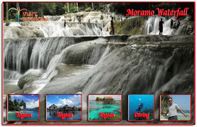
The province of Southeast Sulawesi has many tourism objects, such as marine, natural and cultural tourism. The objects are; - Park object: National Park Aopa Swamp, Napabale park, Morano, waterfall, etc.
- Marine tourism: Sea garden of Hoga Island, Hari island, Labengke, Batu Gong beach, Nirwana beach, etc.
- Cultural tourism: Buton palace, Old fort of Wawoni, Horse-fighting attraction, lakidende resting place, etc.
- Dancing: traditional and contemporary creation
Realize that the annual flow of tourist raise year
by year, the management and development should be encouraged their facilities
such as transportation, hotel, institution and services.
Traditional Costumes
The daily costume for a men consist of Badhu, Bheta,
Sala, and Songko (head tie) which are used at the home. The formal costume for
a men are headdress (Destar), coat, sarong, and trousers. For a women, they
wear Baju Kebaya (shirt), sarong, and flowers on her hair, and are completed
with earrings, necklace, and bracelets.
Kendari
Southeast Sulawesi's capital is
Kendari, seat of government and tourist center of the Province. It lies along
the sloping hill and seaside of Kendari Bay, residence to some 100,000 people.
Kendari boast the manufacture of numerous fine artistic handicrafts, for both
home and office use. Skilled craftsmen reproduce these, originals designs form,
handed-down through the generation, using indigenous roots and ironwood.
Visitors will find a visit to the Berlin Handicraft Center's the Handicraft
Exhibition Center valuable; both belong the local Association of Government
Wives (PKK), and display items, which may be purchased to adorn the most
discriminating setting.
Visitors will find frequent, colorful
ceremonial events in and around Kendari. And, to be present on these occasions
is to be invited to participate. For the closing of any ceremonial event in
Kendari will be highlighted by the local "Lulo Dance" performed by
local men and woman. And all on-lookers are invited to join the dance, as part
of the conclusion and harmonious farewell.
Sanggoleo Golf
Golf
Courses with 18 poles, about 40 hectares width has different level. This Golf
Course is the only sport facility in Southeast Sulawesi and become the cheapest
Golf arena in the world with its good and interesting condition. This Golf
Course is located about 10 km from the downtown to the airlines and can reach
by public transportation or personal vehicle.
Nambo Beach
Nambo Beach is a beach that about 14 km or about 30
minutes to south of Kendari city, which can reach by public transportation or
personal vehicle and also by boat from Kendari port that about 15 minutes. This
beach has spread white sandy; the calm condition is very suitable for bath and
sunbath on the beach.
- Bau Bau; a prosperous town on the island of Pulau Buton, Bau Bau boasts some impressive citadel walls (Kraton / Wolio Royal Citadel), which remain in a good state of repair. Bau Bau offers travellers convenient boat connections to the Maluku Islands, North Sulawesi and the scuba diving hotspot of Tukangbesi. Close to the citadel, the Pusat Kebudayaan Wolio is a memorable cultural centre / museum.
- Kendari; the capital of South-East Sulawesi, Kendari has strong connections with the inland Tolaki community. This bustling town provides a good choice of inexpensive accommodation, and is conveniently situated between Makassar and Wakatobi, serving as an ideal stopover destination for those taking this long journey. Close to Kendari, the snorkelling and diving opportunities around Pulau Hari are excellent.
- Kolaka; easily reached by boat from Bajoe, being an important gateway into the South-East Sulawesi region. Kolaka is known for its clove and cocoa plantations, and has little to tempt tourists.
- Raha; the most sizeable settlement on the island of Pulau Muna, being located in between Bau Bau and Kendari. The leading attractions in the Raha area are without question the lagoon of Napabale, followed closely by Melerua Beach (Pantai Melerua) and the Mabolu Caves (Gua Mabolu).
- Tukangbesi Islands; famed for their world-class diving and now part of the esteemed Taman Laut Wakatobi (Wakatobi Marine National Park). Pula Hoga is the place that most tourists gather in the Tukangbesi Islands, where a number of picturesque, isolated beaches are on hand.
Mamasa Valley

Tana Toraja
- Batutumonga; boasting a very dramatic setting, on the side of the Gunung Sesean. Be sure to pay Batutumonga a visit if you can, since the panoramas of Rantepao and the Sadan Valley are quite breathtaking.
- Makale; Tana Toraja's administrative capital, centred around a large man-made lake. Makale has far less to offer than Rantepoa, although its white washed churches make for a good photograph.
- Rantepoa; the best place for tourists wishing to spend their time exploring the countryside attractions around the cultural island of Tana Toraja. Rantepoa is conveniently close to many places of interest and features a busy regular market (Pasar Bolu). Lots of recreational activities present themselves within the outlying hills, with hiking trails around the Gunung Singki and the villages of Marante and Naggala.
Togean Islands (Togian Islands)

The objects of interest are:

Lahundape (Nipa-nipa Mountain), Wakatobi Island, Batu Gong Beach, Sea Garden of Hari island, Moramo Waterfall, Moramo Bay, Rawa Aopa Watumohai National Park, Buton Island and the Sultanate of Buton, Nirwana Beach and Bone Ogen, Horse Fighting, Napabele and Motonunu Lake, Tamborasi River, Malaha Island, Kaledupa Subdistrict, Tomia Subdistrict, Binongko Subdistrict, Barangka Subdistrict, Bone Subdistrict, Kabawo Subdistrict, Lawa Subdistrict, Maginti Subdistrict, Kusambi Subdistrict, Kabangka Subdistrict, Parigi Subdistrict
South Wakorumba Subdistrict, Maligano Subdistrict, Napabalano
Subdistrict, Tiworo Kepulauan Subdistrict, Pasir Putih Subdistrict, Tongkuno
Subdistrict.
Nature
tourism that is available in Southeast Sulawesi Province are:
1. City of Kendari
2. City of Bau-Bau
3. Regency of Bombana
4. Regency of South Konawe
5. Regency of Konawe
6. Regency of Buton
6. Regency of Buton
7. Regency of Wakatobi
8. Regency of Kolaka
9. Regency of Muna
10. Regency of North Konawe
11. Regency of North Kolaka
For complete information you
could have on the “Text Book Guiding To Indonesia” By F. I. Fatrick.